Marvel Map
A Coal Mining Town
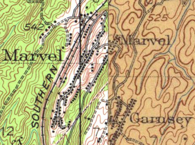
| This
is a detailed map of Marvel, Alabama. As you can see it is a
composite of old USGS maps, taken from the University of Alabama map
archives, linked on this web site. The left side (west) of the map
is dated 1934, while the east side is dated 1910. As you might
expect, things don't line up precisely.
One might expect that the town changed in 25 years, and it has certainly changed since. Today, aerial photos indicate that there is not much remaining of Marvel. The rail line that served the town is long since abandoned. There is little evidence of the many buildings indicated by the small black rectangles indicated on the map. There is more information on the internet all the time. The UA Map Archive has added aerial photos of many areas including Marvel. This link is to a large aerial image of Marvel in 1939, combined with 1950 as well as the 1980 quad sheets of the area. On each of these pages, you will see an image that is large than your computer screen. Use the slide bars to navigate. At an point, you may click on the image you see and it will be replaced with a comparison image. Click again and return. When you are ready to return to this page, go to the lower left hand corner and the will be a return link to this page. Enjoy! Compare: |
 |
|
Thanks to Marshall Goggins for sharing these. |