| Downtown Grade Separation Images | Return to Trackplan | ||||
 |
 |
 |
 |
 |
 |
 |
 |
 |
|||
 |
 |
||||
 |
 |
||||
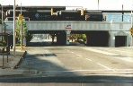 |
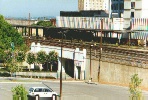
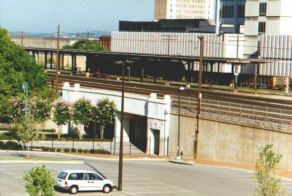
This is a view of the underpass on 20th Street South. The former L&N Station passenger platform is visible on the upper level, dating from 1930-31. This is currently used as Amtrak's station site. |
 |
|||
|
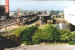
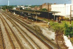
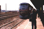
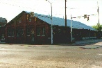
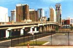
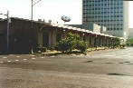
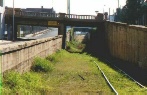
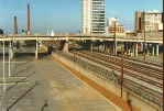
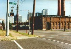
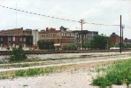
The photos above show the nature of the grade separation with the underpasses and retaining walls. There are three 1920's vintage viaducts in this area, and the second photo shows the 22nd Street viaduct. Almost all of the buildings in this view date from before 1930. The third photo shows the elevated passenger station platform of the L & N Station that replaced the old train shed when the grade separation was built in 1930. The platforms are reached by stairways and the waiting room is underneath, below grade. This is currently serving Amtrak's Crescent from Washington to New Orleans, shown in the fourth and fifth photos. On the model railroad, the 12" wide fold up shelf fills in the space in front of the elevated grade separation track and this front, lower level represents the tracks that parallel the grade separation from Morris Avenue to about 5th Avenue South. In this area the Seaboard came into downtown, and along with the Birmingham Belt Railroad along E Street, now 5th Avenue South served industrial customers south of downtown. When the main tracks were raised and the viaducts built in the 1920's this created some interesting areas with massive retaining walls. A check of the big map shows the nature of the commercial customers here and who the freight stations belonged to. These photos show some of the key elements to model in this area south of the grade separation. Going left to right, one sees the two Seaboard Air Line tracks that are below the 24th Street viaduct in the foreground and the 22nd Street viaduct in the background. Next is another view of the depressed track, with retaining walls passing beneath the 21st and 22nd Street viaducts. The large brick building in the third photo is the old Birmingham Electric Company powerhouse, which served to power the streetcar system. As the street sign shows, we are at 1st Avenue South, at 19th Street. The brick building is the Atlanta, Birmingham and Coast freight house, near interstate 65 at the south end of this area, and is actually on the north side of the grade separation. The gray building with the overhang and the arched doors is the Seaboard Air Line freight house which now serves Alagasco as an office and community meeting space. The last photo shows the types of buildings that will be used for "flats" to disguise the "north" end of the grade separation area on the upper level, to hide the staging yard. The elements of this scene are going to be freely "compressed" and even mixed around as far as location. Part of the fun is the ability to "break the rules" when modeling. I am not a rivet counter. Rather, I am interested in capturing the character of a scene, much as a caricature cartoon captures the subject. |
|||||